1
2
3
4
5
6
7
8
9
10
11
12
13
14
15
16
17
18
19
20
21
22
23
24
25
26
27
28
29
30
31
32
33
34
35
36
37
38
39
40
41
42
43
44
45
46
47
48
49
50
51
52
53
54
55
56
57
58
59
60
61
62
63
64
65
66
67
68
69
70
71
72
73
74
75
76
77
78
79
80
81
82
83
84
85
86
87
88
89
90
91
92
93
94
95
96
97
98
99
100
101
102
103
104
105
106
107
108
109
110
111
112
113
114
115
116
117
118
119
120
121
122
123
124
125
126
127
128
129
130
131
132
133
134
135
136
137
138
139
140
141
142
143
144
145
146
147
148
149
150
151
152
153
154
155
156
157
158
159
160
161
162
163
164
165
166
167
168
169
170
171
172
173
174
175
176
177
178
179
180
181
182
183
184
185
186
187
|
local removeFromList = function(nodeList, element)
for i = 1, #nodeList do
if nodeList[i] == element then
table.remove(nodeList, i)
break
end
end
end
local findNodeByIndex = function(nodeList, nodeIndex)
for i = 1, #nodeList do
if nodeList[i].index == nodeIndex then
return nodeList[i]
end
end
return nil
end
local contains = function(nodeList, nodeIndex)
return findNodeByIndex(nodeList, nodeIndex) ~= nil
end
local findMinFNode = function(nodeList)
local minF = math.maxinteger
local minFNode = nil
for i = 1, #nodeList do
local n = nodeList[i]
local F = n.G + n.H
if F < minF then
minF = F
minFNode = n
end
end
return minFNode
end
local node = function(index, preNodeIndex, G, H)
if index == nil then index = 0 end
if preNodeIndex == nil then preNodeIndex = 0 end
if G == nil then G = 0 end
if H == nil then H = 0 end
local n =
{
index = index,
preNodeIndex = preNodeIndex,
G = G,
H = H,
}
return n
end
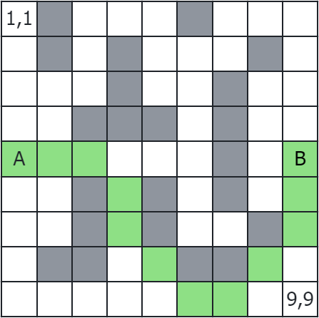
local map =
{
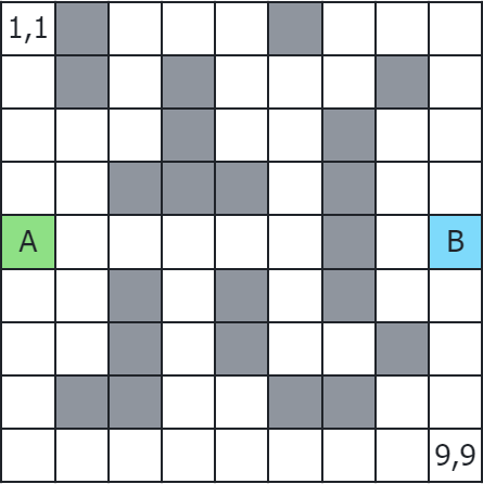
1,0,1,1,1,0,1,1,1,
1,0,1,0,1,1,1,0,1,
1,1,1,0,1,1,0,1,1,
1,1,0,0,0,0,0,1,1,
1,1,1,1,1,1,0,1,1,
1,1,0,1,0,1,0,1,1,
1,1,0,1,0,1,1,0,1,
1,0,0,1,1,0,0,1,1,
1,1,1,1,1,1,1,1,1,
}
local mapH = 9
local mapV = #map / mapH
local mapDataLength = #map
local openList = {}
local closeList = {}
local startNodeIndex = 37
local endNodeIndex = 45
local openObliqueCheck = true
local minFNode = nil
local calculateH = function(nodeIndex)
local projectedXEnd = (endNodeIndex - 1) % mapH + 1
local projectedXNode = (nodeIndex - 1) % mapH + 1
local projectedYEnd = endNodeIndex - (endNodeIndex - 1) % mapH
local projectedYNode = nodeIndex - (nodeIndex - 1) % mapH
local xDis = math.abs(projectedXEnd - projectedXNode)
local yDis = math.abs(projectedYEnd - projectedYNode) / mapH
return xDis + yDis
end
local isReachable = function(nodeIndex)
return nodeIndex > 0 and nodeIndex <= mapDataLength and map[nodeIndex] > 0
end
table.insert(openList, node(startNodeIndex, -1, 0, calculateH(startNodeIndex)))
repeat
minFNode = findMinFNode(openList)
local upLeft = minFNode.index - mapH - 1
if upLeft % mapH == 0 then upLeft = -1 end
local up = minFNode.index - mapH
local upRight = minFNode.index - mapH + 1
if upRight % mapH == 1 then upRight = -1 end
local left = minFNode.index - 1
if left % mapH == 0 then left = -1 end
local right = minFNode.index + 1
if right % mapH == 1 then right = -1 end
local bottomLeft = minFNode.index + mapH - 1
if bottomLeft % mapH == 0 then bottomLeft = -1 end
local bottom = minFNode.index + mapH
local bottomRight = minFNode.index + mapH + 1
if bottomRight % mapH == 1 then bottomRight = -1 end
local neighborList = {upLeft, up, upRight, left, right, bottomLeft, bottom, bottomRight}
local obliqueReachableList = {1,1,1,1,1,1,1,1}
if openObliqueCheck then
local isReachable_up = isReachable(up)
local isReachable_left = isReachable(left)
local isReachable_right = isReachable(right)
local isReachable_bottom = isReachable(bottom)
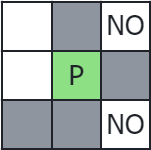
if (not isReachable_left) and (not isReachable_up) then obliqueReachableList[1] = 0 end
if (not isReachable_up) and (not isReachable_right) then obliqueReachableList[3] = 0 end
if (not isReachable_left) and (not isReachable_bottom) then obliqueReachableList[6] = 0 end
if (not isReachable_bottom) and (not isReachable_right) then obliqueReachableList[8] = 0 end
end
for i = #neighborList, 1, -1 do
local n = neighborList[i]
local reachable = isReachable(n)
if (not reachable) or obliqueReachableList[i] == 0 or contains(openList, n) or contains(closeList, n) then
table.remove(neighborList, i)
else
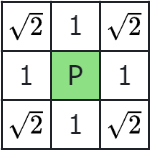
local stepValue = 1
if i == 1 or i == 3 or i == 6 or i == 8 then stepValue = 1.414 end
local node = node(n, minFNode.index, minFNode.G + stepValue, calculateH(n))
table.insert(openList, node)
end
end
removeFromList(openList, minFNode)
table.insert(closeList, minFNode)
until(minFNode.index == endNodeIndex or #openList == 0)
local nodeIndex = endNodeIndex
local path = {}
if contains(closeList, nodeIndex) then
while true do
node = findNodeByIndex(closeList, nodeIndex)
table.insert(path, node)
nodeIndex = node.preNodeIndex
if nodeIndex == -1 then
break
end
end
local toVectorFormat = function(index)
local x = index%mapH
if x == 0 then x = mapH end
return "("..math.ceil(index/mapH)..", "..x..")"
end
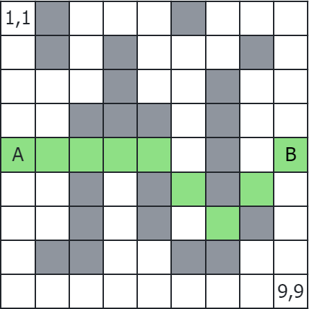
local output = "A* path from "..toVectorFormat(startNodeIndex).." to "..toVectorFormat(endNodeIndex)
.. " distance is "..findNodeByIndex(closeList, endNodeIndex).G.." \n"
for i = #path, 1, -1 do
local str = toVectorFormat(path[i].index)
output = output .. str .. " -> "
end
print(string.sub(output, 1, #output - 4))
else
print("no path found in map.")
end
|
